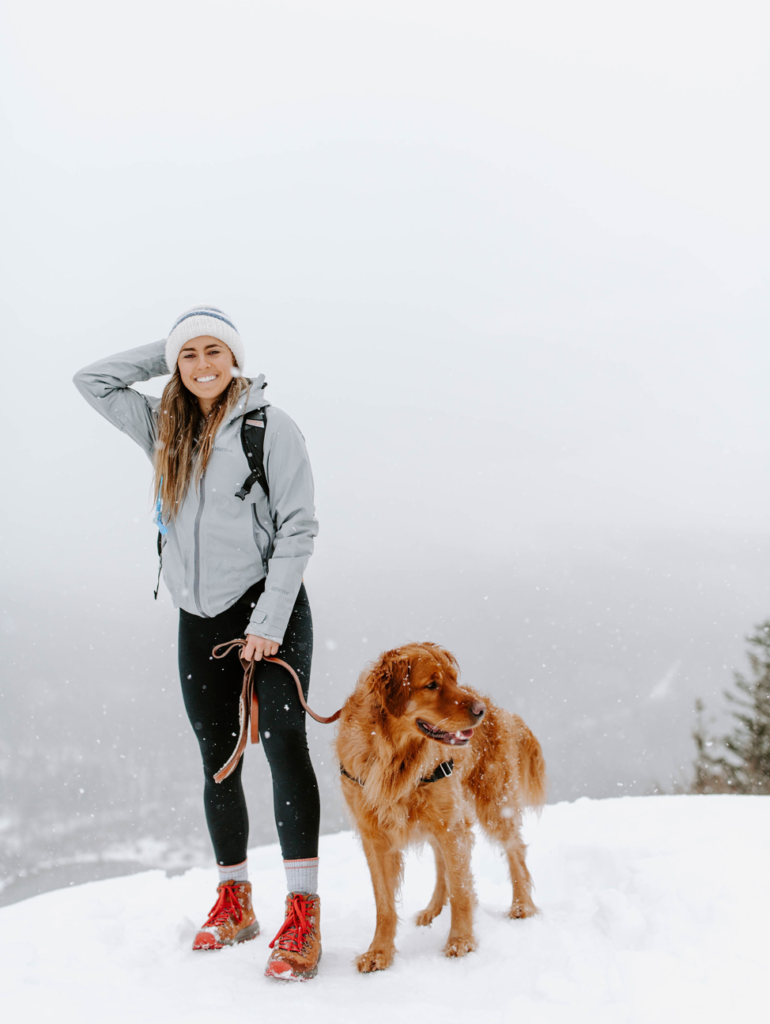
ATOP RATTLESNAKE RIDGE, FEBRUARY 2019
IN THE CITY
Discovery park: 2.8 miles roundtrip, Gain: 140 ft. Highest Point: 325 ft.
NORTH (of the city)
Bellingham: the North Chuckanut Mountain trailhead – there are so many trails off of this route, click here
Blanca Lake: 7.5 miles roundtrip, Gain: 3300 ft. Highest Point: 4600 ft.
Cut Throat Pass PCT: 10 miles roundtrip, Gain: 2000 ft. Highest Point: 6800 ft.
Heather Lake: 4.6 miles roundtrip, Gain: 1034 ft. Highest Point: 2430 ft.
Hidden Lake: 8.0 miles roundtrip, Gain: 3300 ft. Highest Point: 6900 ft.
Lake 22: 5.4 miles roundtrip, Gain: 1350 ft. Highest Point: 2400 ft.
Mount Baker
Mt. Pilchuck: 5.4 miles roundtrip Gain: 2300 ft. Highest Point: 5327 ft.
Skyline Divide, North Cascades: 9 miles roundtrip, Gain: 2500 ft. Highest Point: 6563 ft.
EAST
Bandera Mountain, North Bend: 8 miles roundtrip, Gain: 3400 ft.
Highest Point: 5240 ft
Colchuck Lake: 8.0 miles roundtrip, Gain: 2280 ft. Highest Point: 5580 ft.
Granite Mountain: 8.1 miles roundtrip, 3,730 feet
Icicle Road, Leavenworth: 5 miles, great for snowshoeing in the winter
Little Si: 4.7 miles roundtrip, Gain: 1300 ft. Highest Point: 1550 ft.
Mount Si: 7.1 miles roundtrip, 3,267 feet
Mailbox Peak: 9.4 miles roundtrip, Gain: 4000 ft. Highest Point: 4822 ft.
The Enchantments: 18 miles one way, Gain: 4500 ft. Highest Point: 7800 ft.
Lake Colchuck in Leavenworth: 7.7 miles roundtrip, 2,319 feet
Rattlesnake Ridge: a short 35 minute drive from the city and is my typically go-to hike! It’s beautiful and great views overlooking the lake below, 5.1 miles total
Snow Lake : 7.2 miles, Gain: 1800 ft. Highest Point: 4400 ft.
SOUTH
Dewey Lake at Chinook Pass: 6.0 miles roundtrip, Gain: 600 ft. Highest Point: 5900 ft.
Granite Creek Trail: 8.8 miles roundtrip, Gain 2270 ft, highest point: 3070 ft.
Garfield Ledges
Ira Spring: 6.5 miles roundtrip, Gain: 2420 ft. Highest Point: 4320 ft.
Mount Fremont fire lookout: 5.6 miles roundtrip, Gain: 800 ft. Highest Point: 7200 ft.
Meadowdale County Park Trail: 2.5 miles roundtrip, Gain: 425 ft. Highest Point: 425 ft.
Mt. Adams: 12 miles roundtrip, Gain: 6700 ft. Highest Point: 12276 ft.
Naches Peak Loop, Rainier National Park: 3.2 miles roundtrip Gain: 600 ft.Highest Point: 5850 ft.
Summit Lake, Mt. Rainer: 6.1 miles Gain: 1300 ft. Highest Point: 5800 ft.
Spray Park: 8 miles Gain: 1700 ft. Highest Point: 6500 ft.
Summit Lake: 6.1 miles roundtrip, Gain: 1300 ft. Highest Point: 5800 ft.
Tolmie Peak, Mount Rainier: 7.5 miles roundtrip, ain: 1100 ft. Highest Point: 5900 ft.
WEST
Mount Ellinor, in the Olympics: 6.2 miles roundtrip Gain: 3300 ft. Highest Point: 5944 ft.
Cape Alava : 9.4 mile round trip, Gain: 100 ft. Highest Point: 350 ft.
Mt. Walker : 4.0 miles roundtrip, Gain: 2000 ft. Highest Point: 2804 ft.
Mount Storm King: 4 miles roundtrip, Gain: 2065 ft. Highest Point: 2600 ft.
Lena Lake: 7.2 miles roundtrip, Gain: 1300 ft. Highest Point: 2000 ft.
Dungeness Spit: 11 miles round trip, Gain: 130 ft. Highest Point: 130 ft.
Hurricane Hill: 3.2 miles roundtrip, Gain: 650 ft. Highest Point: 5757 ft.


Hello.This post was extremely interesting, particularly because I was looking for thoughts on this topic last Thursday.
Wow, thanks for the info. Please take a look at my new blog site for women
https://regwomanover50.blogspot.com/